Monday, August 5, 2013

The Rain Forest: Part 2, Ketchikan

Our final night was spent in Ketchikan, once declared the most disgraceful, vice-riddled city in America (no doubt due to the twenty or so brothels lining Creek Street, as well as the open alcohol consumption and gambling during the Prohibition). 

A view of Creek Street and some of the surviving houses of ill-repute, 
re-purposed as shops.

However, that was long ago, and with the repeal of the Thirteenth Amendment, and the closing of the last brothel in the 1950's, it is now a favorite stop for tourists and cruise ships, alike, with a well-developed shopping district along the harbor. 

For those who venture farther into the town, be prepared for a good walk. In my last post, I mentioned that these islands are not flat, and nowhere is that more apparent than Ketchikan.

What passes for a sidewalk in this town.

In fact, those parts of the town that aren't built over the water are built up the sides of hills so steep, in one case a trolley was installed for pedestrians.

(Note the trolley and track behind the totem pole)


A creative approach to reaching the front door.

The town even added a fish ladder to help the salmon up Ketchikan Creek.
(though most likely for other reasons than the steepness, but still...)

As an interesting side note, the hotel we stayed at was called the Inn at Creek Street / New York Hotel. The Inn at Creek Street seemed self-explanatory, but not the New York part. Turned out this hundred-year-old hotel was originally owned by Japanese immigrants (a not uncommon ethnic group in old Alaska) who immigrated through Ellis Island (no idea how they ended up there) and then settled in Ketchikan (which is about as far from New York as one could get). They were so pleased to be in America they named their hotel after the first city they stayed in. Being a fan of old historic buildings, I loved this hotel with all its antiques and period furnishings.

The bedside stand, right out of the '40's!
(Inn at Creek Street/ New York Hotel)

And last, but not least, one of the real reasons I loved this town? A friendly feline (and only the second one I saw on the entire trip through Alaska, besides the mayor of Talkeetna).


And so ends my trip through Alaska, and nearly three weeks of paradise.
 If you have any thoughts or comments, feel free to post a comment below or email me at ellen.lindseth@gmail.com.


Saturday, August 3, 2013

The Rain forest: Part 1, Sitka

After the mountains and glaciers and tundra of the first two weeks of our travels, the lush, hilly landscape of the rain forest took me by surprise.

The islands are not flat, as you can see.
 (the town of Sitka is in the foreground)

Richly forested, relatively temperate in climate, and with what once seemed an inexhaustible bounty of fish and fur, I could see why this beautiful area had tempted the Russians to set up shop in 1799. Given the name of Redoubt Saint Michael (a redoubt being a precursor to a fort), the now-named Sitka was the epicenter of nearly seventy years of Russian military and cultural influence in the area, influence that is still visible today.

A cannon on top of Castle Hill, Sitka.
(note the imperial double eagle of the tsar.)

Throughout the coastal regions and down the Aleutian chain, one can't help but notice all the Russian Orthodox churches, and one of Sitka's most famous buildings is the residence of Bishop Innocent, built in 1843. It is one of three surviving examples of colonial Russian architecture in North America, it has been superbly restored by the National Park Service, right down to matching the wallpaper and reupholstering the furniture with fabric from the original manufacturer.

Where Bishop Innocent slept (which would've been a challenge since he was reportedly over six feet tall)

Where he would greet important guests. (and check out that samovar!)

His personal desk, designed and built by him.

Two notable things about Bishop Innocent: one, he was the architect of the present St. Michael church in downtown Sitka (it was built to his plans after the original church burned down). 

This is his personal chapel in his residence, 
to give you some idea of how beautiful the Russian Orthodox churches are.

And two, he played a major role in calming the tensions between the Russian military and the indigenous Tlingit people. Unlike so many missionaries, he didn't insist on the Tlingits abandoning their religious beliefs. Instead, he showed how Christianity echoed what they already believed, thus allowing the old ways to coexist with the new.

Which brings us to the real settlers of Sitka: the Tlingits. And their cultural influence, which extends back nearly 10,000 years, is also very visible today.

One of many examples of totem poles preserved in Sitka National Historic Park.

There's a wonderful walking/jogging path that takes you past these beauties, 
with the ocean only another dozen yards or so beyond.

A detail from one.
 I'm guessing a bear since it lacks the prominent front teeth of a beaver.

And me standing by one, just for perspective.

Never designed to last, these intricately carved and painted monuments were basically meant to be huge, disposable party decorations, that either told a story, or described an event, or honored whoever was throwing the party. Thankfully, someone decided to preserve a few for future generations, and Sitka National Historic Park was formed to both mark the 1804 battle site between Russian traders and the Tlingit, and as a cultural heritage center. There are other totem poles and other parks dedicated to them around Alaska, but this is the one I would recommend.


Monday, July 15, 2013

Anchorage: A 'easy' hike up Flattop Mountain

First, let me qualify my title. It wasn't me who thought the hike was easy. In fact, the Parks Service calls it a moderate hike. But I have a lovely friend in her 50's who used to live in Anchorage, and on her to-do list for me was this hike. I should also mention that she and her husband hiked 150 miles across England last summer . . . for fun. But never one to back down from a challenge, Ward and I decided to try it.

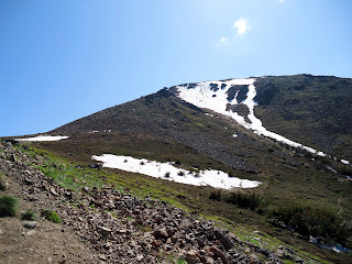
And lovely hike it is, too. Except for the snow, which made the trail look more like this:


And more than once we managed to get off the trail (probably because it was obscured by slush) and ended up scrabbling over fairly steep rock slopes, only to have other hikers pass us on a much easier path. A tip for anyone who might be interested in climbing all the way to the top (which I would highly recommend as the view is breathtaking, and not just literally) there are dabs of orange paint on the rocks indicating the recommended ascent. The problem is they are often only visible on the way down.

Because of where the mountain is, one has a commanding view of the city of Anchorage as well as the Turnagain Arm.
That's Anchorage off the the right, and Turnagain Arm to the left,
 and the Pacific Ocean in the distance.

But the real beauty in the hike, at least for me, was the abundant wildflowers that were in bloom, scattered among the rock like little jewels.


The whole hike took us four hours, and though I might question my friend's 'easy' rating, there is no question the experience was worth it!


Sunday, June 30, 2013

Homer, not once, but twice

On either side of our excursion to Unalaska, we stayed in Homer, which is on the southern tip of the Kenai Peninsula.

The Homer airport with the Pacific Ocean in the distance.

Because we were busy flying in and out, we didn't get to spend as much time there as we might have liked, but we did manage to get out on the Homer Spit, which is 4.5 miles long and extends out into the Kachemak Bay, and is home to the commercial harbor.

Homer Spit from the plane coming in for landing

Besides being the hub of fishing activity,


 and a cool place to view marine wildlife . . .

(Those brown dots are actually sea otters lazing around, a whole raft of them, in fact.)

. . . it is also home to the infamous Salty Dawg Saloon.

The Salty Dawg Saloon (exterior)

The Salty Dawg (interior) with the excellent and very friendly bartender, B.J., working the taps. 
(Just don't ask him to make a Bloody Mary, no matter how fantastic the locals tell you it is! It drives him crazy because it sets off a run of orders that takes him forever to clear.)

While talking to fellow tourists, pilots (one of which Ward knew, which also goes to show what a small world this is), and local fisherman we found out the patron-supplied decor used to be much more extensive, but they had to take it all down to paint the walls and only got a portion of the collection back up. There are still lots of dollar bills signed by visitors from around the world, but the best find to my mind was the Minnesota license plate that said POLICE. B.J. wasn't exactly clear on how it got there (not wanting to incriminate anyone) but he did confirm it came from Minneapolis.

On our second pass through we stopped at the excellent Islands and Oceans Visitor Center, where they had a temporary exhibit on World War II in Alaska, as well as permanent exhibits on indigenous wildlife and the environmental efforts to protect them. We never made it into town during the day, which I'm told has a real artistic vibe, but after dinner we did get a chance to stroll Bishop's Beach, where one can find beautiful, semi-polished rocks brought down by the glaciers as well as naturally occurring coal chunks.


My only regret is we were too early in the season to catch the salmon run, but there's always next time . . .


Monday, June 17, 2013

Cordova, the town that has it all except a bridge.

In the early 1900s, Kennecott Mines was opened,one of the richest copper mines in the world. Deep in the mountains, the mine needed a way to transport all of its copper ore 196 miles to the town of Cordova. Thus the Copper River Northwestern Railway was conceived, and a bridge was built through the mountains.
A sampling of the mountains I'm talking about, with sea fog coming up the fjords.

As the railway approached Cordova, it had to deal with several glacial streams fed by numerous glaciers.

A trestle bridge was built that worked for decades, until the Good Friday Earthquake of 1964, which lifted the town of Cordova six feet, taking one end of the bridge with it. Since the mines had long ago shut down, the railroad secured the bridge from falling, but never rebuilt it. Instead, the Forest Service built a road along the old railroad grade extending from the airport out to the tilting bridge as part of a larger attempt to attract tourists. Unfortunately, Mother Nature had something to say about it, and this bridge to the other bridge washed away sometime in 2012.
(While we were standing here, another large chunk of the road across the river 
broke off and was swept away.)

At first, we were bummed by this development, since the bridge was the only way to reach Child's Glacier, but Ward did a little research, and the next day we took a two hour hike up to the Sherman Glacier, which was stunning in its own right.


Ward walking along the moraine wall of ice, snow, and silt.

In fact, everywhere you look the land around Cordova is being shaped by water. Whether it is the Copper River Delta with all it's mudflats and braided rivers.

Or the slough, where the dusky Canada Goose subspecies resides along with bald eagles and the moose.


Or the glacial rivers, the color of coffee au lait from all the silt (which doesn't harm the salmon at all - it washes right through their gills).
The Copper River at a particularly wide point

Or finally, the rain forest covering the mountain slopes, with its moss-covered landscape fed by sea fog and rain.

The land is alive with water, with a view bound to please almost everyone. I only wish I had more time to hike around. Given the chance, I would come back in a heartbeat. 


Friday, June 14, 2013

Unalaska (Dutch Harbor) and the 1000-mile war

Whenever we mentioned we wanted to fly out to Unalaska, the only other place on U.S. soil to be bombed by the Japanese in World War II, we were told it was too far, the weather too dismal and too dangerous, or else we were met with a blank stare and the question of why? Ward, who is ever ready to take on a challenge, watched the weather forecasts for days, waiting for the right opportunity, which came yesterday, in the midst of our Homer stay.
(I just love how the sweatshirt came with a caution sticker!)

Seven hundred statute miles down the Aleutian Chain from Anchorage, further west than Hawaii (but not nearly as warm) we flew past old volcanoes,
 St. Augustine Island (in sea fog)

active volcanoes,

Mount Pavlof (near Cold Bay, AK)

and beautiful volcanic landscapes that make up the chain.
River on an Unimak Island

The Aniakchak Crater (the least visited National Monument in the country)

After four hours or so, we landed at what once was the U.S. Army's airfield at Dutch Harbor, now the main airport for the island of Unalaska. In our quest for a place to tie down the airplane (perhaps unsurprisingly, the airport doesn't get much in the way of transient aircraft, so they weren't sure where to put us), we ran into Dave, a Medvac pilot, who kindly offered to drive us around the island on an impromptu photo shoot. I was as captivated by the landscape as the World War II buildings that were abandoned at the end of the war. So first, a pictorial ode to the beauty of the island on an absolutely stunning day, so nice I would almost be tempted to move there. Almost.

Dave says there are wild horses on the island, but they were camera-shy for us.

And despite being scarce in the Lower 48, Bald Eagles abound here, 
sometimes congregating in groups of 20-30 birds or more, 
and are found all along the hills surrounding the bays.

And there are indeed signs of the old military encampment everywhere.
An observation post high on the hillside

Panama (rail) Gun Mount for anti-aircraft guns

 Abandoned Quonset hut. 
(Originally the sod would have completely covered it for camouflage.)
Elephant-nose Steel Magazine

Inside the Magazine
(note the office in corner with remnants of a communications panel on the wall inside)

Perhaps the oddest sight to me was to find pillboxes on the sides of residential streets, the town growing up around them, accepting them as part of the landscape, and in some cases using them as fence posts or storage sheds, which, if you know Alaskans, is not out of character.
Pillbox for machine guns w/ town-homes in back

Old Army building in the center of town, re-purposed for civilian use
 next to an abandoned, concrete communications post.

The gorgeous weather couldn't last, of course. We left the next morning in drizzle and fog, but the island was no less beautiful.